The study area is a rectangle 1.2 by 0.6 miles located in northern Orange County California, in the southwestern Coyote Hills.
The land that became Ralph B. Clark Regional Park has a rich history of fossils. Ancient mammoth, ground sloth, ring-tailed cat, camel, whale, bison and turtle remains were found there. See History | OC Parks. See Emery Borrow Pit | University of Texas El Paso. See Fossil Sites within the La Habra Formation of Ralph Clark Park in Orange County California.
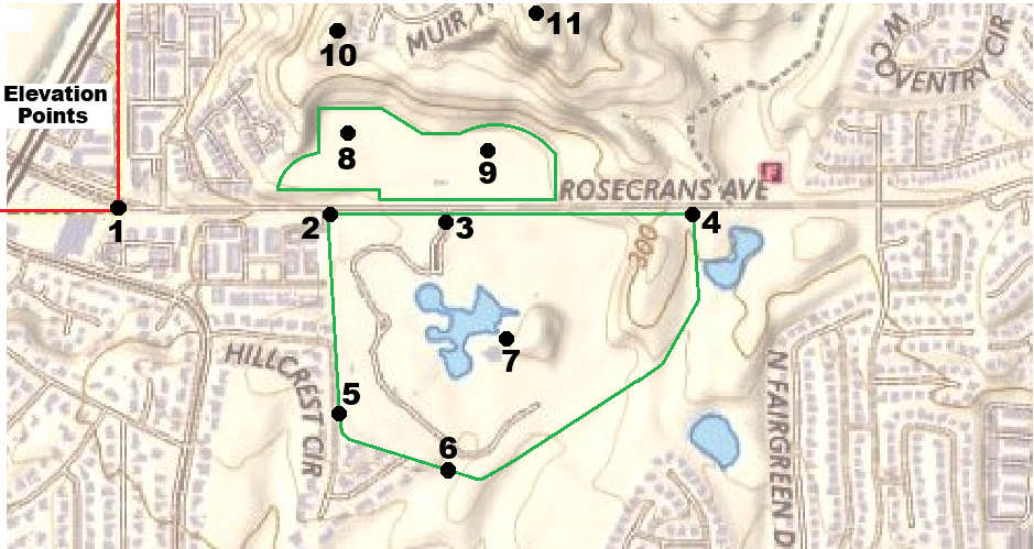
The elevations at 11 points are read from the topo maps below.
001 002 003 004 005 006 007 008 009 010 011
175 265 350 295 275 250 290 300 400 350 500 in 1896
155 240 250 295 245 230 250 255 255 350 480 in 2026
020 025 100 000 030 020 040 045 145 000 020 change
Only points 4 and 10 are at their original elevations.
Imagine a 10-story (100 ft) building at point 3, the park entrance, a 5-story building (45 ft) at point 8, the soccer field, and a 14-story (145 ft) building at point 9, the northeast ball field. That much original land was “borrowed” to elevate the 5 and 91 freeways.
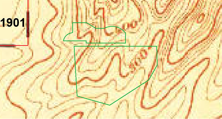
1901 topo map (1896 survey, 25 ft lines) from ngmdb.usgs.gov.
The area is mostly Orange County, founded in 1889. The top left (northwest) corner is Los Angeles County. That county line corner is a major reference point. There are no details shown. The topography disagrees with newer maps especially on the right. The land here generally slopes downward in the southwest direction towards the ocean. Most canyons and creeks flow southwest.
Elevation points in 1896 (feet above sea level)
0o1 0o2 0o3 0o4 0o5 0o6 0o7 0o8 0o9 o10 o11
175 265 375 295 250 250 290 300 400 300 500
175 265 350 295 275 250 275 300 400 345
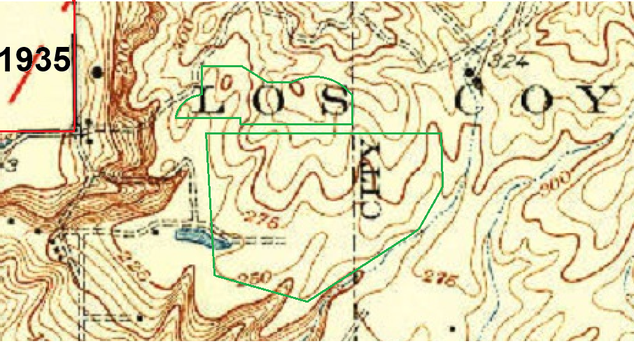
1935 topo (1923 survey, 25 ft lines) from ngmdb.usgs.gov.
The Emery Ranch pond was at the lowest part of the western border of Ralph Clark Park. A dike diverted seasonal creek water into the pond.
Elevation points in 1923 (feet above sea level)
0o1 0o2 0o3 0o4 0o5 0o6 0o7 0o8 0o9 o10 o11
155 250 350 295 275 250 275 300 400 345 480
The oil road was graded. Points 1 and 2 are 20 ft and 15 ft lower.
The cliff top was excavated. Point 11 is 20 ft lower.
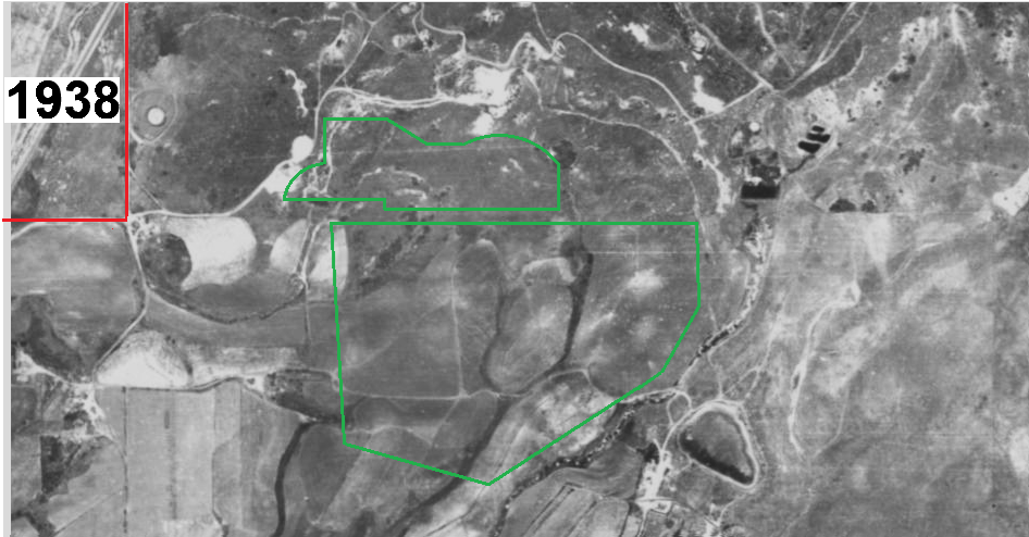
1938 photo from ocgis.com.
The area is mostly Emery Ranch. There are two places with large trees that are likely Emery Ranch structures, at the county line corner point and near the ranch pond. Grey areas are the normal ground cover, coastal sage scrub. White areas are bare earth or dried grass. Dark areas are shrubs or trees.
The old oil road that starts at the county line corner point has 3 or 4 white areas where the ground has been dug out.
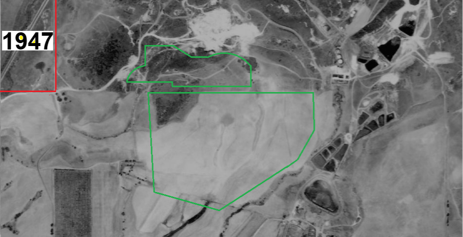
1947 photo from ocgis.com.
State Highway 39 (Beach Blvd) is built, running in a straight diagonal line. The dark area at the top left (northwest) is a grove of native pines, in what is now the communities of Westside and Maison de Fleur along Emery Ranch Road, north of Rosecrans Ave. Some of that pine grove still remains, and some has been replaced with landscaping pine trees.
At the upper right are three oil tanks in a row. Their thin shadows show the sun is almost directly overhead. Without shadows steep slopes are not visible.
The old oil road goes uphill to a large excavation area, white in this photo. There is only one small bent dark line in the whole white excavation area. That must be a steep cliff made by excavators. Originally there were no steep cliffs.
Here the ground color is lighter, except in places where evergreen trees and shrubs are at, such as coast live oak and coyote brush. The 1947 photo is likely from summer or fall.
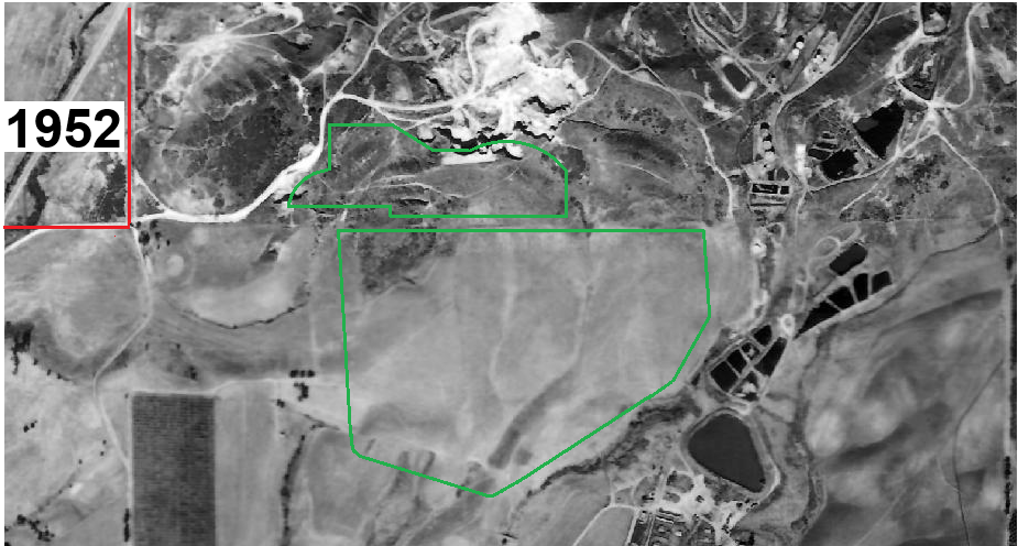
1952 photo from ocgis.com.
Just east of the park are 12 black oil sumps (waste pits) on what is now the Los Coyotes Country Club golf course.
Emerson Little writes in the Fullerton Observer on June 4 2025 about the oil sumps, now called the McColl Superfund Site.
The “McColl Site” plaque on the corner of Sunny Ridge Drive and Rosecrans read “Completion of Construction – October 1997.” Inscribed into the plaque was the following: “Thanks to the diligent efforts of the residents and elected officials of Fullerton, the McColl Site Group, The California Environmental Protection Agency, and the United States Environmental Protection Agency, this former waste site has been restored to a golf course. The work performed makes the site safe for public use and friendly to the environment.”
However, this land in the past has had a history of being used as a disposal area for environmentally hazardous material. According to EnviroStor, the State of California’s Department of Toxic Substances Control (DTSC)’s online data management system, the 22-acre area of land in question was formerly used as a refinery waste disposal facility in the 1940s and 1950s. More specifically, from 1942 to 1946, the area had petroleum waste that “seeped into the soil and groundwater, creating a hazard for the community,” according to the the U.S. Environmental Protection Agency (EPA) website. Refinery waste was left in 12 unlined pits, or sumps, on the site.
The history section of the California DTSC webpage for McColl goes into further detail, stating that “it is estimated that approximately 97,100 cubic yards of contaminated material (72,600 cubic yards of solid waste and 24, 500 cubic yards of contaminated soil) is contained in the waste sumps,” which mostly consisted of “an acidic sludge waste generated during the refining process for high octane aviation fuel during the 1940s.” In the Fifties and Sixties, drilling mud was dumped over some of the sumps to control odors while the Los Coyotes Country Club golf course was being built.
According to the EnviroStor database, homes went up in the area in the late Sixties. In 1978, residents began to seriously complain about odors and health issues, which led to investigations by local, state and federal agencies that found that “the soil and groundwater on the site contained thiophene (THTs); sulfur dioxide, and various volatile organic compounds VOCs) including benzene.”
The EPA was then called in, and their original cleanup plan was “excavation and disposal of wastes at an approved disposal facility,” according to EnviroStor. A State court injunction stopped the contaminated soil from being transferred, which led to the EPA changing its cleanup plans for the soil two more times: once in 1989 and then again in 1993, according to the DTSC website.
My grandparents distinctly remember driving by the area at the time and seeing people in white hazmat suits at the site. In the 1990s, the U.S. Environmental Protection Agency capped the sumps, walled them off from groundwater and lined drainage channels to contain the toxins, according to the federal webpage for “Cleanup Activities” at the McColl Superfund Site.
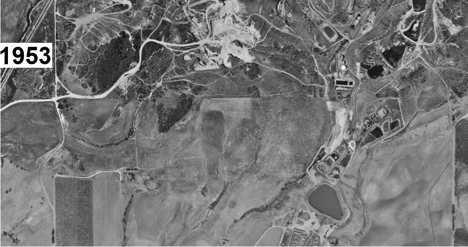
1953 photo from ocgis.com.
The future park boundary overlay is not shown. This higher resolution photo shows more detail!
From the row of 3 oil tanks near the top right, you can see their shadow is on the right, so the sun is on the left. Near the county line corner point, there are trees, a structure (casting a shadow to the right), and an empty lot that is most likely the headquarters of Emery Ranch. This is just south of the intersection of Emery Ranch Rd and Rosecrans Ave.
The white area on the top of the hill is excavated, but mostly the surface. The small cliffs face east or north-east. All of the excavated gravel is carried downhill on the now widened oil road to the county line and Highway 39.
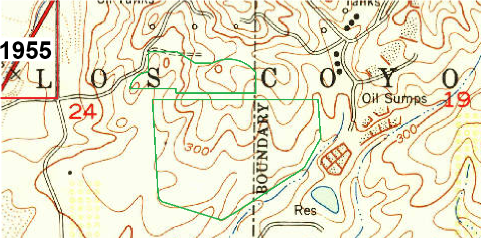
1955 topo (1950 survey, 25 ft lines) from ngmdb.usgs.gov.
Elevation points in 1950 (feet above sea level)
0o1 0o2 0o3 0o4 0o5 0o6 0o7 0o8 0o9 o10 o11
155 250 350 295 250 250 275 300 400 345 480
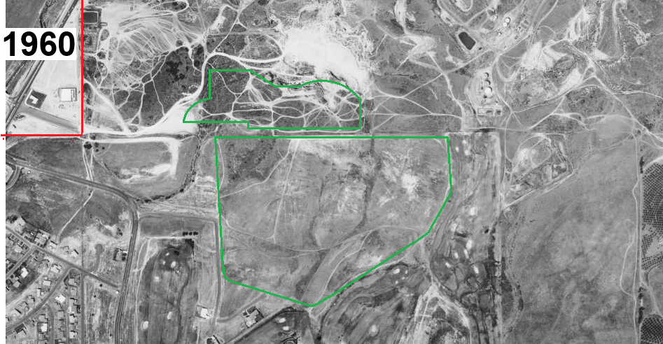
1960 photo from ocgis.com.
Rosecrans Ave extends to the L.A. County border corner point. There is a survey marker on the south sidewalk there. But the property line continues east. North of the line is Fullerton where motorcycle trails are everywhere. The area was called “motorcycle hill”. South of the line is Buena Park where there are no motorcycle trails.
The oil sumps are no longer visible, but 97,100 cubic yards of contaminated sludge remained, and the air had a sulfur odor.
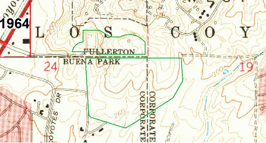
1964 topo (1963 survey, 20 ft lines) from ngmdb.usgs.gov.
Rosecrans Avenue continues east into Orange County as a two-lane street, ending at the rectangular pit, in what is now soccer field at the northwest corner of Clark Park. There are still telephone pole stumps along the border of the soccer field. They were put there in the early 1960’s for safety to keep vehicles from driving into the deep pit. The 1964 topo (1963 survey) shows the pit, but the 1960 photo does not.
Elevation points in 1963 (feet above sea level)
0o1 0o2 0o3 0o4 0o5 0o6 0o7 0o8 0o9 o10 o11
155 250 350 295 245 250 275 220 400 345 480
The soccer field pit was excavated. Point 8 is 80 ft lower.
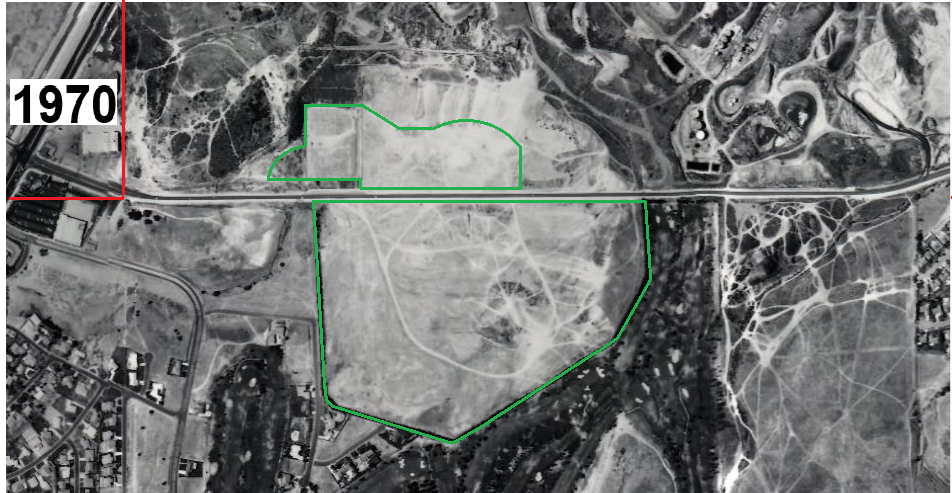
1970 photo from ocgis.com.
The main park was excavated. Points 3 and 7 are 100 ft and 25 ft lower. Light areas are freshly scraped bare ground. Dark areas have vegetation and so have not been not dug out.
A solid border of trees surrounds the main park area. Camel Hill is visible on the east side, and Elephant Hill can be seen near the center. It looks like excavation has stopped and motorcycle trails have formed.
North of Rosecrans was excavated. Point 9 is 145 ft lower. The Emery Borrow Pit was excavated from 1956 to 1973 by the California Division of Highways, which became Caltrans in 1973. Thousands of truckloads of gravel-sand were used to build the Santa Ana and Riverside Freeways.
Rosecrans Ave was excavated. Point 2 is 10 ft lower. Point 3 is 100 ft lower. It had two lanes initially.
The soccer field pit was filled in. Point 8 is 45 ft higher. The Rosecrans grading dug out the short access road to the soccer field pit.
Rich fossil beds were exposed. Soon the public demanded that the site be preserved, so the County of Orange acquired the property in 1974.
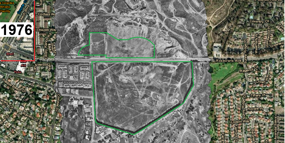
1976 photo from ocgis.com.
Here the colored areas are from 2026. Only the middle grey area is 1976. West of the park, the Buena Tierra community has been graded and constructed.
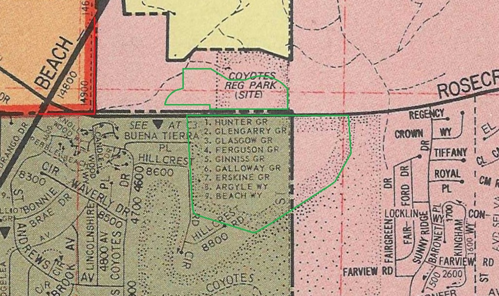
1977 Thomas Guide map.
This shows the boundaries of unincorporated Orange County (yellow) and the cities of La Mirada (Orange), Buena Park (grey) and Fullerton (pink). Los Coyotes Regional Park (site) is labeled.
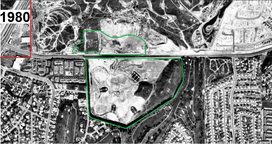
1980 photo from ocgis.com.
South of Rosecrans, Clark Park (Phase 1) was constructed from 1979 to 1981.
The parking lots have just been paved. Most of the area is white where the ground has been graded. On the east (left) side the Camel Hill and Elephant Hill areas are dark with vegetation. The motorcycle trails are gone. The southern top of Camel Hill shows the white area that’s still there. It formed from groundwater deposits.
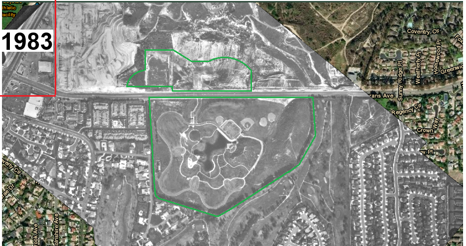
1983 photo from ocgis.com.
The Interpretive Center (Phase 2) was constructed from 1982 to 1986. It opened in 1987.
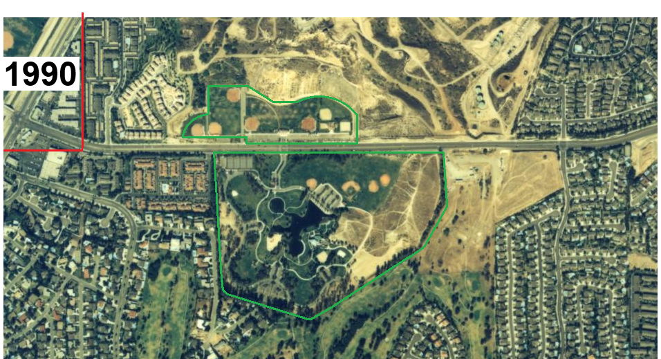
1990 photo from ocgis.com.
North of Rosecrans, Clark Park (Phase 3) was constructed from about 1984 to 1988.
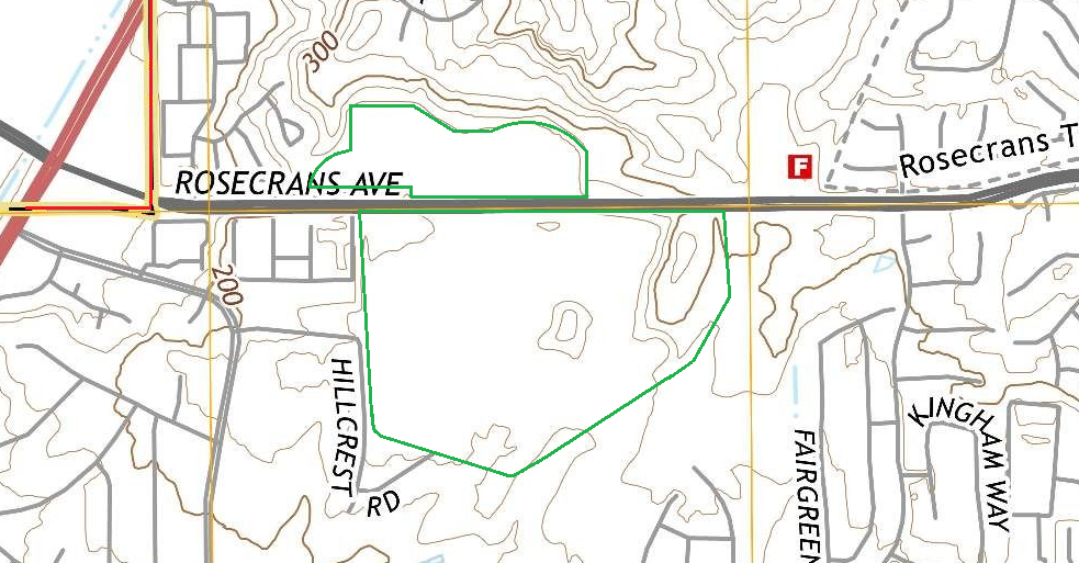
2015 topo map (1988 survey, 20 ft lines) from ngmdb.usgs.gov.
Elevation points in 1988 (feet above sea level)
0o1 0o2 0o3 0o4 0o5 0o6 0o7 0o8 0o9 o10 o11
155 240 250 295 245 230 250 255 255 345 480
By 1988 development and land movement ended. The topography remained the same from 1988 on.
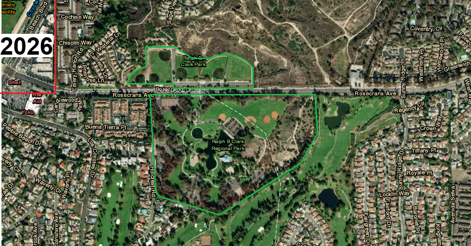
2026 photo from ocgis.com.
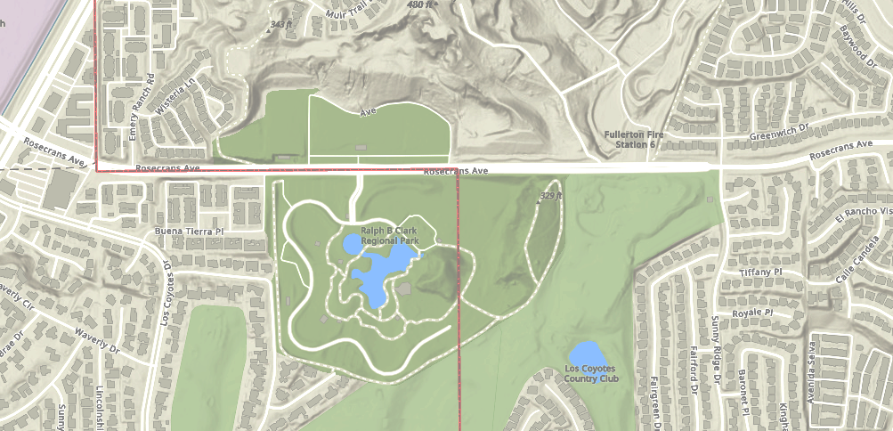
2026 topo from gis.cityoffullerton.com.
This shaded map shows the most topographic detail. It says the exact elevations of point 10, 343 ft and point 11, 480 ft.